Whenever you need to create a detailed model of an area — for surveying, accident reconstruction, or any other purpose — creating a point cloud can be the best way to get the job done.
An accurate, detailed, high-resolution 3D point cloud model is an important element in accurate 3D model creation. If your organization is seeking a new way to create digital reconstructions of physical spaces or structures, drones capable of generating point clouds may be the perfect tool for you.
By learning more about point clouds — what they are, how you generate them, different approaches, and use cases — you can make an informed decision about integrating these digital tools into your workflows.
Point clouds: It’s all about perspective
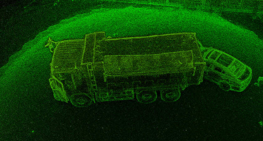
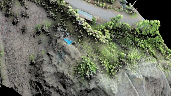
What exactly is a point cloud? It is a collection of data points mapped in three dimensions. Each point has its own X, Y and Z values according to where it is in space. Some point clouds can have exceptionally high resolution, at hundreds of individual points per square meter, to show exactly what is in a 3D space.
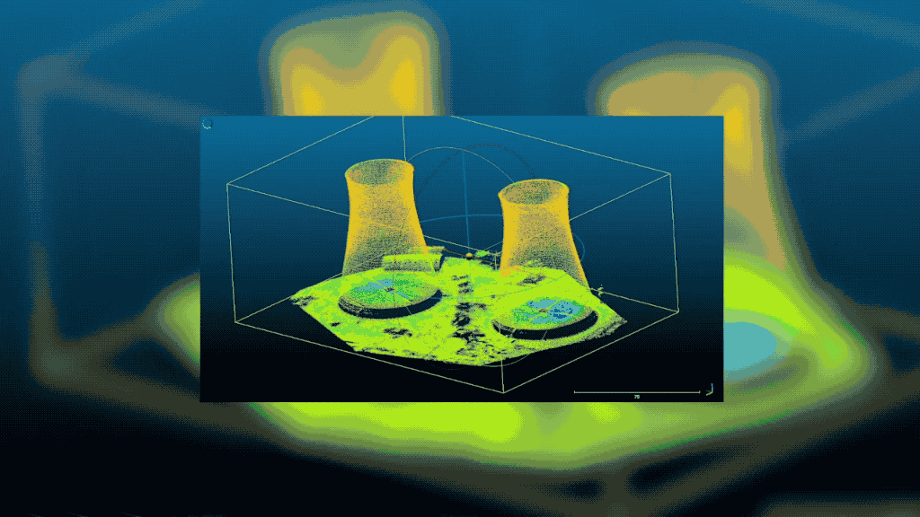
The points together denote the surfaces of objects and terrain features within an area, which allows surveyors or inspectors to create extremely accurate 3D maps and models of those areas. The cloud itself is not the map, however. You need another data set other than just the elevation data points to create a more fully featured model.
To generate these point clouds, you need the proper equipment and a new perspective of your target area: namely, an aerial view. By flying an unmanned aerial vehicle (UAV) over your area of choice, you can collect the necessary information on elevation and topography.
Advanced drones equipped with the latest light detection and ranging (LiDAR) sensors can build out point clouds in a single pass. A drone using a photogrammetry camera system can assemble a point cloud as one of the outputs from the resulting three-dimensional image. In either case, the resulting cloud is a detailed and accurate picture of the scanned area.
How point clouds work
How exactly does the point cloud creation process work? While the exact details depend on whether your drone is equipped with LiDAR sensors or photogrammetry equipment, the procedure is the same.
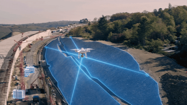
Your UAV flies over a chosen area, scanning with its payload of sensors. The data point information is then assembled into a usable form through point cloud processing software, like DJI Terra.
To get to the result of a 3D point cloud, the software will either add context to a vast number of points detected by laser pulses or generate points based on a collection of photos taken from multiple angles. This depends on whether you favour LiDAR or photogrammetry, and that in turn will be decided by the type of surveying or mapping you're doing.
The difference between LiDAR point clouds vs photogrammetry point clouds
The two main methods of creating a point cloud from UAV data, LiDAR and photogrammetry, each have their ideal use cases. You may end up using both at various times.
Companies that frequently map complex, vegetated areas may gravitate toward LiDAR, while businesses dealing with clear sightlines and needing a lower-cost solution may start with photogrammetry, but the decision can't be reduced to one or two issues. Comparing the technologies side by side is a useful exercise when deciding how to outfit your UAVs.
LiDAR
LiDAR scanning involves frequent laser pulses which then bounce back to the sensor. By using inertial measurement and satellite positioning data, the drone's LiDAR sensor determines exactly where in space a point is located.
The collected points become a LiDAR point cloud when assembled by specialised point cloud software. This is a high-accuracy scanning method, though it needs to be matched with other data to add more detail to the maps, including colour.
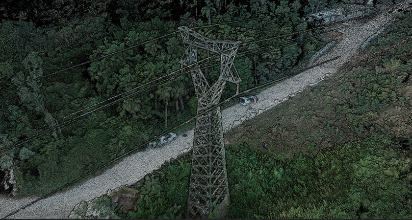
LiDAR is great for mapping items too small to be detected by other methods. For instance, if you need to map thin cables or power lines as part of your point cloud, you can do so by collecting LiDAR data. The technology also works in low-light conditions and can reach the ground through layers of foliage.
Additionally, because LiDAR point clouds are direct measurements, the file sizes are relatively smaller when compared to the high-resolution photographs used for photogrammetry. This means that post-processing of LiDAR data is faster than extracting point clouds from photogrammetry models, and this can be a major factor for customers who prioritise efficiency or who have time-sensitive missions.
Since cloud-based LiDAR software is less common than photogrammetry tools, the actual process of compiling the raw data into a point cloud may require an on-site employee with technical training. The costs may also be higher, including the need for more powerful drones to carry the specialised sensors.
Photogrammetry
Photogrammetry assembles data projections out of photographs. This is an affordable and straightforward approach to surveying and mapping, and the software needed to work with photogrammetry data is available through a simple, cloud-based model.
Using photogrammetry is flexible. You can decide how quickly to fly the drone, depending on the level of detail needed for the maps or 3D point clouds you are generating for the project at hand.
Depending on the level of detail you opt for and the size of the area you're surveying, the UAV camera will take either hundreds or thousands of photographs. These pictures have colour and, in addition to becoming 3D point clouds, can be assembled into a map or a 3D model.
Since photogrammetry is based on photography, you do need a light source for it to work, whether natural or artificial. With that said, the general user-friendliness of the method can make up for the inconvenience of seeking the right conditions. The relatively low barriers to entry can make this a great first method for a company just starting out making 3D point clouds or other data models.
Uses of point cloud modelling
Once you've generated 3D point clouds, what do you use them for? The use cases will differ based on your industry, but they all focus on the need for accurate 3D models.
Once you've determined a good use case for an accurate 3D point cloud, you simply have to find the right drone and information gathering payload for your circumstances.
The right point cloud modelling drones and payloads
What type of drone will your team be flying on your next point cloud generation assignment, and what sensor will it have equipped? When working with DJI, you have options, including:
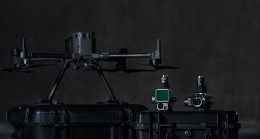
- Drone hardware: Drone choice is determined by mission and work conditions. The Matrice 300 RTK is a good choice for 3D point cloud generation. It can operate in a wide variety of environmental conditions and deliver 55 minutes of flight time while equipping your sensor package of choice.
- LiDAR payload: The Zenmuse L1 is the first UAV LiDAR system available through DJI, and its feature list is impressive. This solution enables the mapping of 240,000 points per second with a single return or up to 480,000 points per second with three returns. An integrated RGB camera enables true-colour point cloud outputs, and Point Cloud LiveView in DJI Pilot lets you verify if your data collection is proceeding correctly.
- Photogrammetry payload: For users preferring photogrammetry, DJI offers the Zenmuse P1. This system can take a photo every 0.7 seconds to quickly build accurate and detailed models for conversion into 3D point clouds.
Source: DJI