In the second part of our Navigator blog series we delve into the bathymetric LiDAR’s diverse range of use cases and applications. From mapping the unexplored to safeguarding hydraulic structures, the Navigator is not just a tool but a transformative solution for a multitude of challenges across various industries.
Navigating non-navigable waters
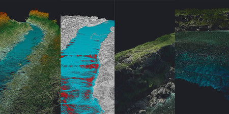
One of the Navigator's standout capabilities is its ability to map areas that are otherwise inaccessible by boat or crewed aircraft. This opens up new possibilities for detailed and accurate mapping of remote or hazardous locations, ensuring comprehensive data collection without compromising safety.
Versatile applications across industry:
- River and coastal oceanography: Gain unprecedented insights into riverbed composition, coastal erosion, and sediment, enhancing environmental monitoring and conservation efforts.
- Lakes: Map lake bottoms with precision, supporting ecological studies, resource management, and recreational planning.
- Hydraulic structure safety: Monitor and assess the condition of dams, levees, and other hydraulic structures, ensuring their integrity and operational safety.
- Dredging and maritime works: Optimise dredging operations and maritime construction projects with accurate underwater topography, reducing risks and improving efficiency.
- Natural disaster response: Rapidly assess flood impact, storm damage, and other natural disaster effects on underwater landscapes, aiding in quicker, more effective response strategies.
- Underwater archaeology: Discover and document underwater archaeological sites with minimal disturbance, opening new chapters in our understanding of history.
- Surface water hydrology: Enhance water management practices by accurately mapping river channels, floodplains, and watershed boundaries, contributing to more sustainable water resource management.
The YellowScan Navigator is designed to empower professionals across various fields, offering a new lens through which to view and understand the underwater world. By enabling access to previously unreachable areas and providing detailed, accurate data, the Navigator supports informed decision-making and innovative research.