


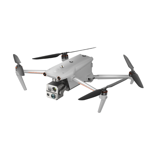
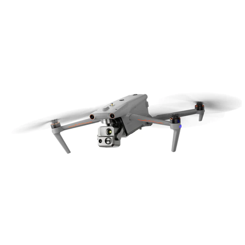
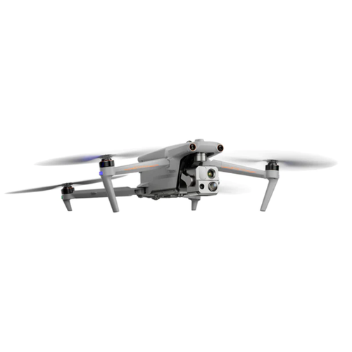

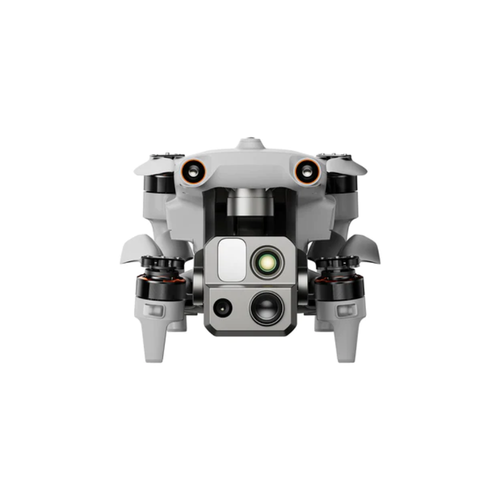

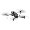
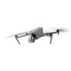
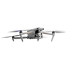
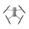
Autel EVO Max 4T (Thermal)
- 50MP Camera
- 640x512 Thermal Resolution
- Hot-Swappable Batteries
- IP43 Weather Rating
- 42 min Max. Flight Time
- 19km Transmission Range
- 4km Service Ceiling
- 12 m/s Max. Wind Resistance
- 720° Obstacle Avoidance
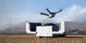
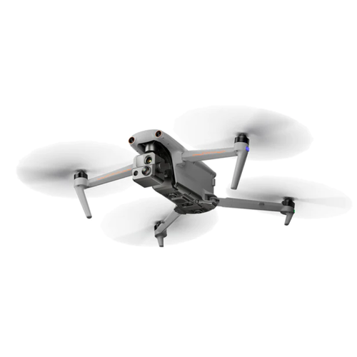
Autel EVO Max 4T brings you advanced autonomy. It assesses complex environments to create real-time 3D flight paths for unparalleled obstacle avoidance. Advanced sensors make flight in GPS unavailable areas possible, and the incredible thermal camera unlocks new object identification and tracking scenarios. With a foldable, weather-resistant design, the series is as portable as it is capable.
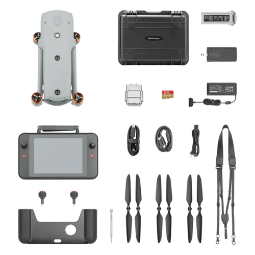
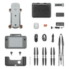
- 1x Aircraft
- 1x Battery Charger + Power Cable
- 1x Spare Propeller (pair)
- 1x Screwdriver
- 1x Smart Controller V3(sticks included)
- 1x Smart Controller Lanyard
- 1x Smart Controller Cover
- 1x Smart Controller Spare Joystick (pair)
- 1x RC Charger
- 1x RC Charging Cable
- 1x Data Cable
- 1x Manuals (Quick Guide, Packing list)
- 1x Rugged Case
-
Aircraft
Weight 3.5 lbs (1600g, battery and gimbal included) Max. Take-off Weight
4.41 lbs (1999 g)
Dimensions 562*651*147 mm (unfolded, incl. propellers)
318*400*147 mm (unfolded, excl. propellers)
257*145*131 mm (folded, excl. propellers)Diagonal Wheelbase 1.53 ft (466mm) Max Ascent Speed 8m/s Max Descent Speed 6m/s Max Horizontal Speed (windless near sea level) 23m/s
*Maximum speed in Ludicrous Mode is 19m/s when operating in EU regions.
Max Service Ceiling Above Sea Level 13,124ft (4000m) Max Flight Time (windless) 42 mins Max Hovering Time (windless) 38 mins Max Wind Resistance 27mph*
*Take-off and landing can withstand wind speeds up to 27 mph (12 m/s).IP Rating IP43 Max Tilt Angle 35° Max Angular Velocity Pitch: 300°/s; Yaw: 120°/s Operating Temperature -4°F to 122°F (-20℃ to 50℃) Internal Storage
The internal storage is 128G, and the remaining available space is about 64G* (Remaining available space will vary with different firmware versions)
Operating Frequency 2.4G/5.2G*/5.8G/900MHz*
*5.2GHz is only applicable for FCC, CE, and UKCA regions. 900MHz is only applicable for FCC regions.GNSS
GPS+Galileo+BeiDou+GLONASS
Transmitter Power (EIRP) 2.4GHz: <30dBm (FCC), <20dBm(CE/SRRC/MIC)
5.8GHz: <27dBm (FCC/SRRC), <14dBm (CE)
5.15-5.25GHz: <23dBm (FCC/CE)
902-928MHz: <30dBm (FCC)
5.65-5.755GHz: <27dBm (MIC)Hovering Accuracy Vertical:
±0.1 m (Vision System enabled);
±0.3 m (GPS enabled);
±0.15 m (RTK enabled);
Horizontal:
±0.15 m (Vision System enabled);
±0.3 m (GPS enabled);
±0.1 m (RTK enabled);Wi-Fi Protocol
802.11a/b/g/n/ac/ax
Support 2 x 2 MIMO Wi-Fi
Wi-Fi Operating Frequency
2.400 - 2.4835 GHz;
5.150 - 5.250GHz (CE/FCC/MIC);
5.725 ‒ 5.850 GHz*(Except MIC)
Wi-Fi Transmitter Power (EIRP)
2.400 - 2.4835 GHz
FCC:<30dBm; CE/SRRC/MIC:<20dBm
5.150 - 5.250GHz
FCC/CE/MIC<22dBm
5.725 ‒ 5.850 GHz
FCC/SRRC: <21dBm
CE: <14dBm
-
Gimbal
Mechanical Range Pan: -135° to 45°
Tilt: -45° to 45°
Roll: -45° to 45°Controllable Range -90° to 30° Stable system 3-axis mechanical gimbal (pan, tilt, roll) Max Control Speed (pitch) 200º/s Angular Vibration Range <0.005°
-
Zoom Camera (Telephoto)
Sensor 1/2" CMOS, Effective pixels: 48M Lens Focal length: 11.8-43.3mm (35mm, equivalent: 64-234mm)
Aperture: f/2.8-f/4.8Exposure Compensation ±3EV 0.3EV/step ISO Range Normal Mode:
Auto: ISO100 ~ ISO6400
Manual:
Photo: ISO100 ~ ISO12800
Video: ISO100 ~ ISO6400Shutter Speed Photo: 8s ~ 1/8000s
Video: 1s ~ 1/8000sMax Photo Size 8000×6000 Max Video Resolution 7680×4320
-
Wide Camera
Sensor 1/1.28 CMOS, Effective pixels: 50M Lens FOV: 85°
Focal length: 4.5 mm (equivalent: 23 mm)
Aperture: f/1.9
AF motor: PDAF focusExposure Compensation ±3EV 0.3EV/step ISO Range Auto:
Photo: ISO100~ISO6400
Video: ISO100~ISO64000 (Night scene mode: up to ISO64000)
Manual:
Photo: ISO100~ISO12800
Video: ISO100~ISO6400Shutter Speed Photo: 8s ~ 1/8000s
Video: 1s ~ 1/8000sMax. Video Resolution 3840×2160 Photo Size 4096*3072
-
Thermal Camera
Thermal Imager Uncooled VOx Microbolometer Lens FOV: 42°
Focal length: 13mm
Aperture: f/1.2Infrared Temperature Measurement
Accuracy±3℃ or reading ±3% (using the larger value) @ambient temperature range from -4℉ to 140℉ (-20℃~60℃) Video Resolution 640*512 Photo Size 640*512 Pixel Pitch 12 um Temperature Measurement Method Center measurement, pot measurement, rectangular measurement Temperature Measurement Range -4℉ to 302℉, 32℉ to 1022℉ (-20°C to 150°C, 0 to 550°C) Temperature Alert High and low temperature alarm thresholds, reporting coordinates and temperature values Palette
White Hot/Black Hot/Searing/Rainbow/Grey/Ironbow/Cold and Hot
-
Laser Range Finder
Measurement Accuracy ± (1 m + D×0.15%)
D is the distance to a vertical surfaceMeasuring Range 5m to 1.2km
-
Image Transmission
Operating Frequency 2.4G/5.8G/900MHz*
*900MHz is only applicable for FCC regions.
Max Transmission Distance
(unobstructed, free of interference)12.4 miles/20km (FCC), 4.9 miles/8km (CE) Independent Networking Autel Smart Controller V3 Transmitter Power (EIRP) 2.4GHz: <28dBm (FCC), <20dBm (CE/SRRC/MIC)
5.8GHz: <28dBm (FCC/SRRC), <14dBm (CE)
902-928MHz: <28dBm (FCC)
5.65-5.755GHz: <31dBm (MIC)
-
Autonomy
Visual Positioning Flight Indoor: Horizontal error ≤1.18in/3cm (At least have texture at one direction)
Outdoor:
Daytime: Within 1640ft (500m) flight height, horizontal error < 0.01 *relative height
Night: Manual flight is controllable within 328ft (100m) flight heightVisual Positioning Return-to-Home Within 984ft (300m) flight height, horizontal error of Return-to-Home point < 11.8in Automatic Obstacle Rerouting High Speed Obstacle Rerouting: Flight speed up to 33.6mph (15m/s) when Min. safety distance to obstacle is 4.9ft (1.5m)
High Precision Obstacle Rerouting: Flight speed up to 6.7mph (3m/s) when Min. safety distance to obstacle is 1.6ft (0.5m)Multi-target Recognition and Tracking Target identification types: people, vehicles, boats
Number of targets detected: 64
Comprehensive recognition accuracy: > 85%
-
Millimetre-wave Radar Sensing System
Frequency 24GHz/60GHz*
*Please fly safely and comply with your local laws and regulations to use 60GHz.Sensing Range
60GHz Radar:
Upward: 0.98-787.4in (0.3-20m)
Downward: 5.9-3149.6in (0.15-80m)
Forward and Backward: 0.98-98.43ft (0.3-50m)
24GHz Radar:
Downward: 2.62-39.4ft (0.8-12m)FOV
Horizontal (6dB): ±60°/±22° (24G/60G)
Vertical (6dB): ±30°/±20° (24G/60G)Operating Environment
The 60GHz millimetre-wave radar sensing system supports all-weather obstacle avoidance for glass, water, wires, buildings, and trees. Its obstacle avoidance distance varies with the obstacle's ability to reflect electromagnetic waves and its surface size.
The 24Ghz millimetre-wave radar supports downward sensing, and its sensing range varies by the ground material. For example, the sensing range of cement ground is 12 meters, and the sensing range of grass with a thickness of more than 3cm is less than 6 meters.
-
Visual Sensing System
Obstacle Sensing Range Forward: 19.7-1220.5in (0.5-31m)
Backward: 19.7-984.3in (0.5-25m)
Sideward: 19.7-1023.6in (0.5-26m)
Upward: 0.66-85.3ft (0.2-26m)
Downward: 0.98-75.5ft (0.3-23m)FOV Forward/Backward Sensor: 60°(H), 80°(V)
Upward/Downward Sensor: 180°(sideward), 120°(forward & backward)Operating Environment
Forward, Backward, Sideward, Upward: The surface has rich texture, under sufficient lighting environment (>15 lux, normal indoor fluorescent lighting environment)
Downward: The surface is a diffuse material with a reflectivity >20%
(walls, trees, humans, etc.), under sufficient lighting environment (>15 lux, normal indoor fluorescent lighting environment)
-
Radar and Visual Sensing Systems
Sensing Range Forward & Backward: 11.8-1968.5in (0.3-50m)
Sideward: 19.7-1023.6in (0.5-26m)
Upward: 0.66-85.3ft (0.2-26m)
Downward: 0.49-262.5ft (0.15-80m)
FOV
Forward/Backward Sensor: 80°(H), 120°(V)
Upward/Downward Sensor: 180°(sideward), 120°(forward & backward)Operating Environment
Forward, Backward, Upward, Downward: supports all-weather obstacle avoidance for glass, water, twigs, buildings and high voltage lines. At least one of the 2 conditions should be met: sufficient lighting or the obstacle has strong reflection ability to electromagnetic waves.
Sideward: The surface has rich texture, under sufficient lighting environment (>15 lux, normal indoor fluorescent lighting environment)
-
Autel Smart Controller V3
Screen 7.9 inch, 2000nits max. brightness, 2048*1536 resolution Battery Capacity: 5800mAh
Battery Type: Intelligent Lithium Ion Battery
Voltage: 11.55V
Energy: 67Wh
Charing time: 120minsOperating Time 3 hours (Max. brightness)
4.5 hours (50% brightness)Max Transmission Distance
(without interference)12.4 miles/20km (FCC), 4.9 miles/8km (CE) IP Rating IP43 Storage 128G GNSS GPS+GLONASS+Galileo+Beidou Operating Temperature -4°F to 104°F (-20℃ to 40℃) Wi-Fi Protocol WiFi Direct, Wi-Fi Display,
802.11a/b/g/n/ac
Support 2 x 2 MIMO Wi-FiOperating Frequency 2.400 - 2.4835 GHz;
5.150 - 5.250GHz*(MIC only);
5.725 ‒ 5.850 GHz*(Except MIC)Transmitter Power (EIRP) 2.400 - 2.4835 GHz
FCC:<23dBm; CE/SRRC/MIC:<20dBm
5.150 - 5.250GHz
MIC:<17dBm
5.725 ‒ 5.850 GHz
FCC/SRRC:<22dBm
CE:<14dBm
-
Aircraft Battery
Capacity 8070mAh Voltage 14.88V Battery Type LiPo 4S Energy 120wh Net Weight 1.15 lbs (520g) Charging Temperature -4° F to 113° F (-20ºC to 45ºC)
When the temperature is lower than 41° F (5° C), the self-heating function will be automatically activated. There should be at least around 10% of the remaining power for heating.)Hot Swap Support
How Long Does Postage Take?
- You place an order.
- Processing time (1-2 business days) [This can sometimes be longer, depending on product availability].
- Shipping time 1-6 business days depending on your location.
- Package arrives at your door.
Most times of the year, we will ship your order within 2-5 business days from the time you placed it. During busy seasons it can take longer, and shipping time estimates will be slightly longer. Domestic hipping generally takes about 1-6 business days after your order is created, processed, and shipped within Australia. International shipping generally takes 7-14 business days. We ship all of our packages out of Australia and exact shipping time is based on your proximity to our location.
Do You Ship Worldwide?
Yes! We ship to most countries in the world. Packages shipped to international addresses generally take 7-14 business days to arrive after your order is processed. Note that often orders will be passed to and delivered by your country's local post office. We ship from Australia. For more information about the locations, we ship to, please contact us on +61293180566 or email us info@spheredrones.com.au.
What Carriers Do You Use?
Here at Sphere Drones, we use a number of shipping carriers depending on the nature of the order. Below is a list of carriers we currently use and the shipping options.
Residential Options:
- Free Shipping on orders $499.01+
- $10 Flat Rate Shipping on orders below $199
- $15 Flat Rate Shipping on orders above $199.01 and below $499
- Australia Post Express Post
- Australia Post Parcel Post
- DHL Express
Commercial Options:
- Free Shipping on orders $499.01+
- $10 Flat Rate Shipping on orders below $199
- $15 Flat Rate Shipping on orders above $199.01 and below $499
- Australia Post Express Post
- Australia Post Parcel Post
- DHL Express
- TNT Overnight Express
- TNT Road Express
Pickup Options:
- Warehouse Pickup (Sydney Only)
We also use FEDEX, TNT and DHL to service our international clients. For more information on shipping and handling, please contact us on 1800 549 821 or email us info@spheredrones.com.au.
Talk to us about Autel EVO Max 4T (Thermal)
For inquiries or more information, please fill out the form below, and our team will contact you as soon as we can.