


As we look at the current state of enterprise drone inspections, we see a tremendous potential for good, largely wasted by complexity and inefficiency. A divided world among hardware manufacturers, mapping software, and fleet management software forces users to piece-meal together solutions relying on brittle integrations that easily break.
Procurement and integration challenges are just the beginning. But, it doesn't end there. There are even deeper challenges when it comes to operations and data accuracy. The lack of autonomy and automation built-in traditional manual drones makes operations harder, riskier and time consuming. Relying on manual data capture, even with experienced pilots, leads to re-flights, errors and inconsistent data. This is why, by and large, commercial drones programs have largely not taken off.
Skydio takes a completely different approach. Our goal is to provide a complete solution from drone to cloud that works out of the box and leverages AI-driven autonomy to unlock simpler, more efficient and accurate inspections. Our journey started a few months ago with the release of Skydio 3D Scan and Skydio Cloud for S2. The response from customers across industries has been exciting.
With Skydio 2 and 3D Scan, we are going to be able to efficiently capture high-quality images for 3D Reconstruction, saving us tons of time and energy in the field. It’ll be easier for the pilots, safer for our assets, and faster for our teams.
Jarvis Worton, Global Platform Technology Analyst. Jacobs
At the same time, many asked us to bring the same stack to the X2 airframe with an optimized sensor for inspection. With a ruggedized, foldable airframe, longer flight time and range, and Skydio Enterprise Controller, X2 is indeed an exceptional platform for enterprise grade inspections even in challenging conditions and environments. Today, we are excited to report that our integrated solution for autonomous commercial drone inspection is now available also on the X2 platform.
More specifically, we are proud and excited to announce the general availability of the integrated solution for autonomous commercial drone inspection, composed of the following three components of our enterprise stack:
- Skydio X2 Color
- Skydio 3D Scan for X2
- Skydio Cloud for X2
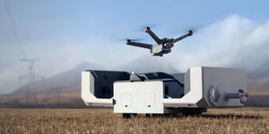
The Skydio X2 Color Drone - Built for Inspection
Skydio X2 pairs our ground-breaking autonomous flight engine with a portable and robust drone for enterprise and public sector customers. Skydio X2 Color is available in both the internet-connected X2E model and the offline X2D system and delivers these characteristics with a camera optimized for inspections.
The new X2 Color features a single sensor, color-only gimbal. While the color lens on the X2 Color/Thermal that we first introduced in May offers ~46° HFOV, which is ideally suited for situational awareness with longer standoff distances, the new X2 Color features a wide-angle lens with ~80° HFOV. This new system is ideal for detailed up-close inspections and other mapping applications, and is capable of capturing down to 0.65 mm ground sample distance (GSD). If you want to explore more about why GSD is the most important metric to evaluate for enterprise inspection, we encourage you to read our Enterprise Drone Inspection Ebook.
X2 Color boasts a portable and easy-to-deploy design with foldable arms and pinch-release antennae. Combined with the vision-based navigation system that removes the need for the infamous calibration dance of legacy manual drones, X2 Color allows you to be airborne in under 75 seconds, so you can get to work faster than ever before.
To operate in tough conditions, X2 Color offers a ruggedized airframe that is both light and highly durable, thanks to cutting-edge build quality with hyper-strength composites. The X2 platform offers a 14° to 109° F temperature operating range.
With up to 35 minute flight time on a single battery, longer station time allows the inspector to operate more efficiently, completing more jobs in less time.
For ground control operations, the Skydio Enterprise Controller offers a robust data link over the 5 GHz radio frequency, leading to a longer 6 km wireless range, which means operators can operate confidently around larger and more complex structures. Long bridges, tall towers, large investigation scenes, all of them are inspection targets for X2 Color.
Always remember that Skydio designs, assembles, and supports its products in the U.S. X2 however, goes beyond, offering the highest levels of supply chain security demanded by the US government, including compliance with National Defense Authorization Act (NDAA).
Skydio 3D Scan - Autonomous Drone Inspection Data Capture with AI Precision
Drones today are used to document complex assets from privileged aerial vantage points. This imagery can then be fed into photogrammetry software to create digital twins. Capturing complete and accurate data sets with traditional drones is, however, insanely painful and inefficient. To thoroughly document complex physical assets, manual drone operators must deal with two sub-optimal methods: 1. use rudimentary waypoint-based 2D flight patterns, which provide some level of automation, but fail to capture detail due to their limited top-down viewpoints, or 2. manually flying around the structure, which somewhat increases the level of detail, but requires long standoff distances to avoid collisions and usually fails to provide consistent coverage and strong GSD.
Skydio 3D Scan, now available for X2, is an adaptive scanning drone software that offers the best of both worlds by fully automating the data capture process needed to document the most complex structures and scenes from every angle with comprehensive high-resolution coverage. The AI-driven workflow is as simple as setting an inspection volume, defining GSD and overlap, and then tracking progress with the assistance of augmented reality features, while the drone takes care of the rest. And by bringing 3D Scan to the X2 platform and X2 Color specifically, we are offering a solution that leverages the new wide angle sensor, longer flight time, and robust data link to document structures in the toughest conditions more efficiently.
At the end of the flight, the Edge Model Viewer allows the operator to view a simplified 3D model of the scanned scene on a laptop or the ground controller. This ground-breaking feature allows the inspector to instantly browse through their set of inspection photos in the most intuitive way possible: spatially indexed in 3D.
3D Scan produces a set of geotagged photos that inspectors can use directly for visual inspections, or process with the photogrammetry software of their choice to generate digital twins with a level of detail and quality that the industry hasn’t seen before. 3D Scan is compatible with a broad ecosystem of photogrammetry solutions. We have worked closely with the market leaders in data processing to ensure high quality results, including Bentley ContextCapture, DroneDeploy, and RealityCapture.
Source: Skydio


