


Pix4D provide many industry solutions for adaptable and professional workflows by the integration of drone based technology. The Pix4Dag will convert your multispectral images into precise reflectance and index maps. This program is perfect for your agricultural tasks to analyse your crops on a high-tech level to process locally when and where you want.
By using index maps like NDVI it can generate high resolution orthomosaics with RGB images.

CAPTURE
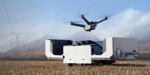
You can use any camera, any image and even Pix4Dcapture flight planning app on your mobile or tablet for the capturing of drone field operations, flight review, and optimal data capture.
PROCESS
By being able to choose offline processing on Pix4D desktop, you have full control over data, without needing an internet connection. You can also choose online processing instead for fully automated, hardware free results on Pix4D cloud.
ANALYZE
On desktop you can gain access to advanced editing features, quality control, and measurements. For the cloud, monitor projects over time, use the drawing overlay for construction, and automatic NDVI map for agriculture.
SHARE
Now you can easily collaborate and annotate projects online to then share maps, models, and analytics with a simple URL.
Purely from the images you capture you can create the following to gain the data you require:
-
Reflectance Maps
Used to capture plants reflectance at different spectrum bands. By doing so it stores this value at the level of the pixel to give you access to information on the health of vegetation as well as the foundation.
The different light intensities create the sensor response as well as taking in the sun factor.

-
Index Maps (e.g. NDVI, NDRE)
These maps combine information from the reflectance maps in order to highlight plant health differences that are directly or indirectly related to problems that include water stress, nutrient deficiencies, pests and more.

-
Orthomosaics
By using RGB images, high resolution maps are made with corrected perspective and uniform scale. This gives you geographic data from an aerial perspective.

-
Application Maps
These maps aggregate and visualise the values derived from the index maps. They are exported as a shapefile (*.shp) and can be directly imported into farm specific equipment for later application in the field.

You can purchase the MONTHLY, YEARLY or PERPETUAL software.
Give us a call or email us at Sphere and one of our team members will be able to answer any further questions or enquiries.